uCrop – Image Cropping Tools
Promote your images and photos from the filing cabinet to your evaluation data and technical reports!
Purpose
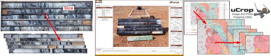
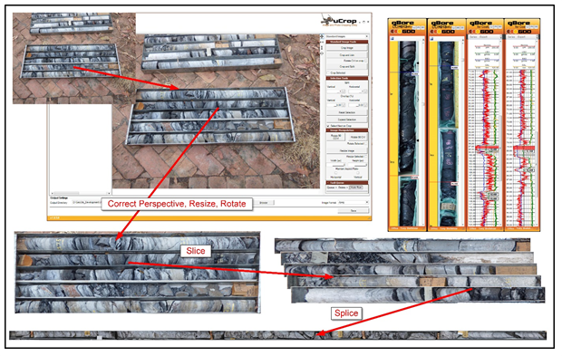
uCrop crops photos and raster image; it can correct perspective, slice and dice an image into its logical components, and rotate and resize images.
uCrop automates the processing of similar images, renaming them according to their type and attributes.
Specific image type capabilities -
· Drill core tray and in-barrel photos
· Crop and correct perspective
· Slice, splice and assign depths for data / core visualisation, evaluation and reporting
· Percussion chips
· Crop, slice and dice
· Assign depths
· Maps, satellite images and similar
· Georeference un-georeferenced images
· Cropping and georeferencing of map and image sections
· Assign or change coordinate systems and projections
· Process large images (>1GB).
Basic Image Cropping
· Cropping
· Crop one or more images from a photo or scanned document
· Rotation and Resizing
· Images can be set to be rotated during the crop process
· Images can be resized (resampled) to a uniform pixel size
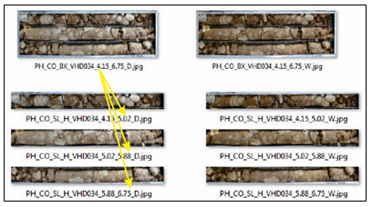
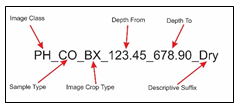
· By default uCrop appends a sequential number to the original image name
· For specific image types such as drill core or georeferenced maps, the name is assembled using data from the input file list
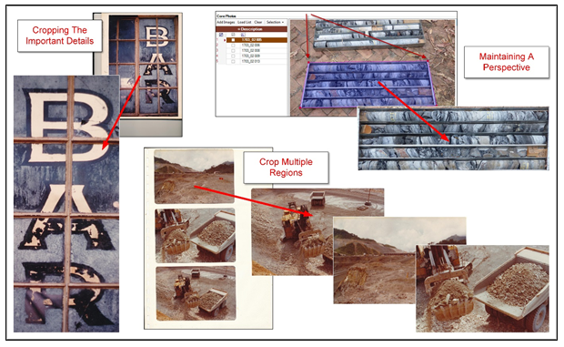
Advanced Cropping
Crop Core and Chip Trays
· Crop Trays
· Correct perspective
· Re-raster to uniform image size
· Assign holename, depths, tray number etc. as required
· Create Slices
· Split the mask on one direction, either horizontally or vertically, to create slices for use in synchronous display, visualisation, evaluation and reporting
· Interpolate slice depths
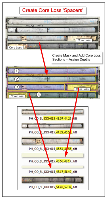
· Include core loss sections
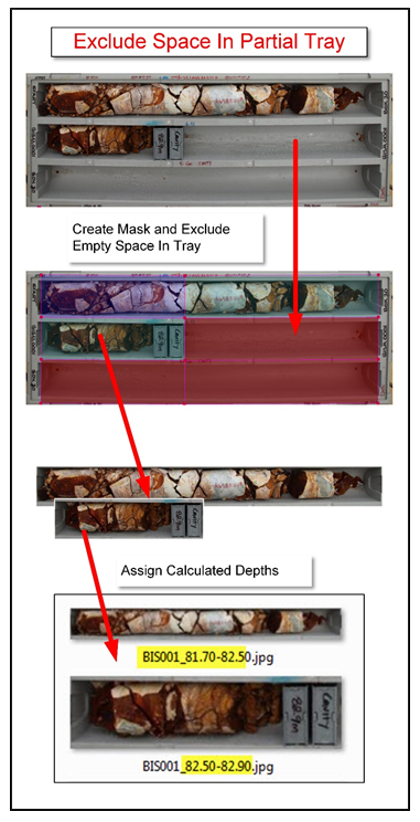
· Manage partial and distorted trays
· Create Combined Strips
· Crop slices and combine to create continuous strips
· Or combine existing slices to assemble the strip image
· uCrop applies a perspective correction to restore the image to an orthogonal view
· The uCrop mask is stretched to the visible shape of the tray. The perspective is then corrected when the image is cropped
· Create a Grid
· Split the mask in two directions for chip tray cells
· And rotate if required
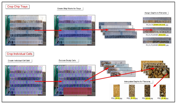
· Exclude Segments
· Exclude selected segments (slices or cells) from the mask
· Such as a partially filled core tray row.
· Manage Core Loss in Core Trays
· Identify core loss sections and adjust core slice image depths accordingly
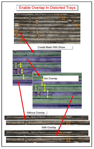
· Specify Overlapping Segments
· Sometimes images can be badly distorted for a variety of reasons…..
· uCrop can apply a slice or cell overlap to ensure each slice captures the entire relevant area
Crop And Georeference Maps and Satellite Images
· uCrop crops georeferenced images, (raster images that know where they are at…). And it can georeference those that are not
· uCrop can work in UTM or decimal degree coordinates, and convert between different systems given the relevant EPSG magic numbers.
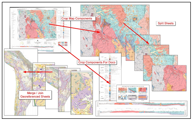
· Crop, split and merge maps and other spatial images
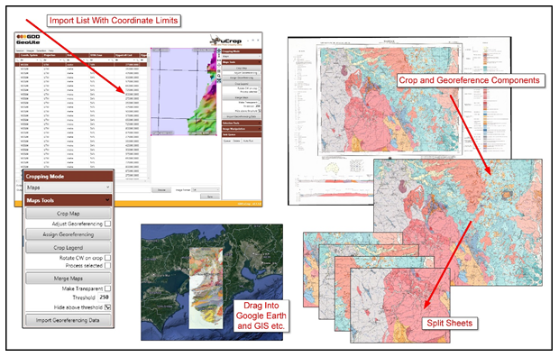
· Georeference images that are not
· Re-reference cropped components
· Change coordinate systems and projections
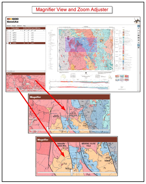
· Use a magnified view for corner accuracy
Cropping Automation
uCrop options allow you to -
· Delay the image processing using a processing queue
· Run (and save) the queued crops as required
· Export the processing queue to a file so it can be restored and run at a later time
· Scheduled the processing to run on other machines on your network when things get gigundeous!
By default, uCrop will crop and process an image in real time, which may take a while for large images
· Use the cropping queue to defer the processing until all image are defined
· Core photos taken with a camera frame system such as uLog / uSnap can be cropped in bulk automatically using the same crop mask settings.
Key Features and Benefits
Promote your images and photos from the filing cabinet to a useful component of your evaluation data collection and technical reports as ‘linked objects’!
(See – ‘Integrated Use of Linked Objects’)
· Very simply, uCrop makes your images more accessible, useful and valuable
· Create consistent quality, uniformly sized images for analysis, evaluation and data reporting
· Enables easy cropping, slicing, dicing and splicing of your favourite geological logging, (or any other) images saving valuable time
· Generates CSV data files to link the cropped images to your geological database where that functionality exists
· Applies consistent naming conventions to your cropped images
uCrop is an advanced image cropping tool that allows you to –
Crop, Slice and Dice
· Crop, rotate, correct perspective and rename one or more sections from an image making them accessible and useful
· Re-raster / resize cropped components such as core trays to standard pixel sizes for further processing, and for uniform size in documents
· Slice and dice core and chip trays, assigning interpolated depths to each component for use in visualisation tools, databases and reports
· Specify overlapping segments to ensure complete capture of a given slice or section
· Name the cropped components with relevant attributes
Georeference
· Crop and georeference map images from both georeferenced and non-georeferenced original sheets, saving them as fully georeferenced TIFF files
· Assign or change coordinate systems
· Make your maps and other images available to all spatial display tools and systems
uCrop Automation
· Reduce image cropping and processing times even more through automation and background processing
· Include information such as hole no., depths, limits and coordinate system information georeferencing as a CSV file
· Crop multiple images, or predefine an individual mask and queue the cropping saving significant time and effort.
· Crop area and settings are retained for subsequent images speeding the process
· Crop multiple images as a batch using a common mask where possible
· Defer the image processing for execution later following mask setup
· Save defined cropping tasks for processing later, or even on different machines
Specific Image-Type Functionality
· Core table, core tray and chip tray photos
· When processing images taken using the uLog camera frame, reduce photography and processing time by up to 90% over the old manual methods
· Slice core trays to create individual images for each row, with interpolated depths
· Functions to manage and account for both core loss in the core strips, and partially filled rows in core trays
· Function to define an overlap for each segment to ensure the full coverage of the strip when boxes, (or photos) are wonky….
· Split chip trays using a 2D grid to create individual cell images, again with interpolated depths.
· Splice strips to produce a single core-strip image for viewing and reporting in various gPick applications.
· Name the cropped images consistently using the relevant details; (hole no, depth from, depth to, photo type as an example)
· Create a catalogue list of the cropped images with hole no. and depths etc. for linking to logging data your favourite geological database
· Correct image perspective of photos taken at an angle
· Georeferenced images and maps
· Create georeferenced sections of original maps
· Quickly and easily create cropped georeferenced images for field use or with your database or GIS applications